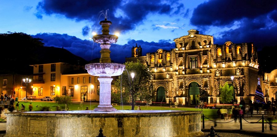
The fountain
The octagonal basin visually organises the open centre.
Historic centre · Cajamarca, Peru
Welcome to Plaza de Armas de Cajamarca, widely recognized as the central Plaza de Armas of Cajamarca. Located in the heart of Cajamarca, Cajamarca, Peru (Plaza de Armas de Cajamarca → Cajamarca → Cajamarca → Peru), this destination serves as a primary hub for travelers visiting the region, offering historical context, practical orientation and respect for a living public space.
Cajamarca sky right now
Current conditions and a 7-day forecast for Plaza de Armas de Cajamarca, at 2,722 m elevation. The forecast refreshes often.
A square to read on foot
About Plaza de Armas de Cajamarca: it sits in Cajamarca’s historic centre, Cajamarca, Peru (Plaza de Armas de Cajamarca → Cajamarca → Cajamarca → Peru). The national tourism inventory classifies it as a cultural manifestation and historic place; it records a square plan, a net area of 12,139 m² and an elevation of 2,722 metres. MINCETUR ↗
This space is linked to the 1532 encounter between the forces of Francisco Pizarro and the Inca Atahualpa. Its history deserves care: it is not a static backdrop, but an urban space holding Andean memory, the colonial period and present-day life. PromPerú ↗
At its centre stands the carved basin: an octagonal stone fountain that public sources date to the end of the 17th century. Notice its proportions, its relationship with the facades and the changing light before hurrying onward.
Square gallery
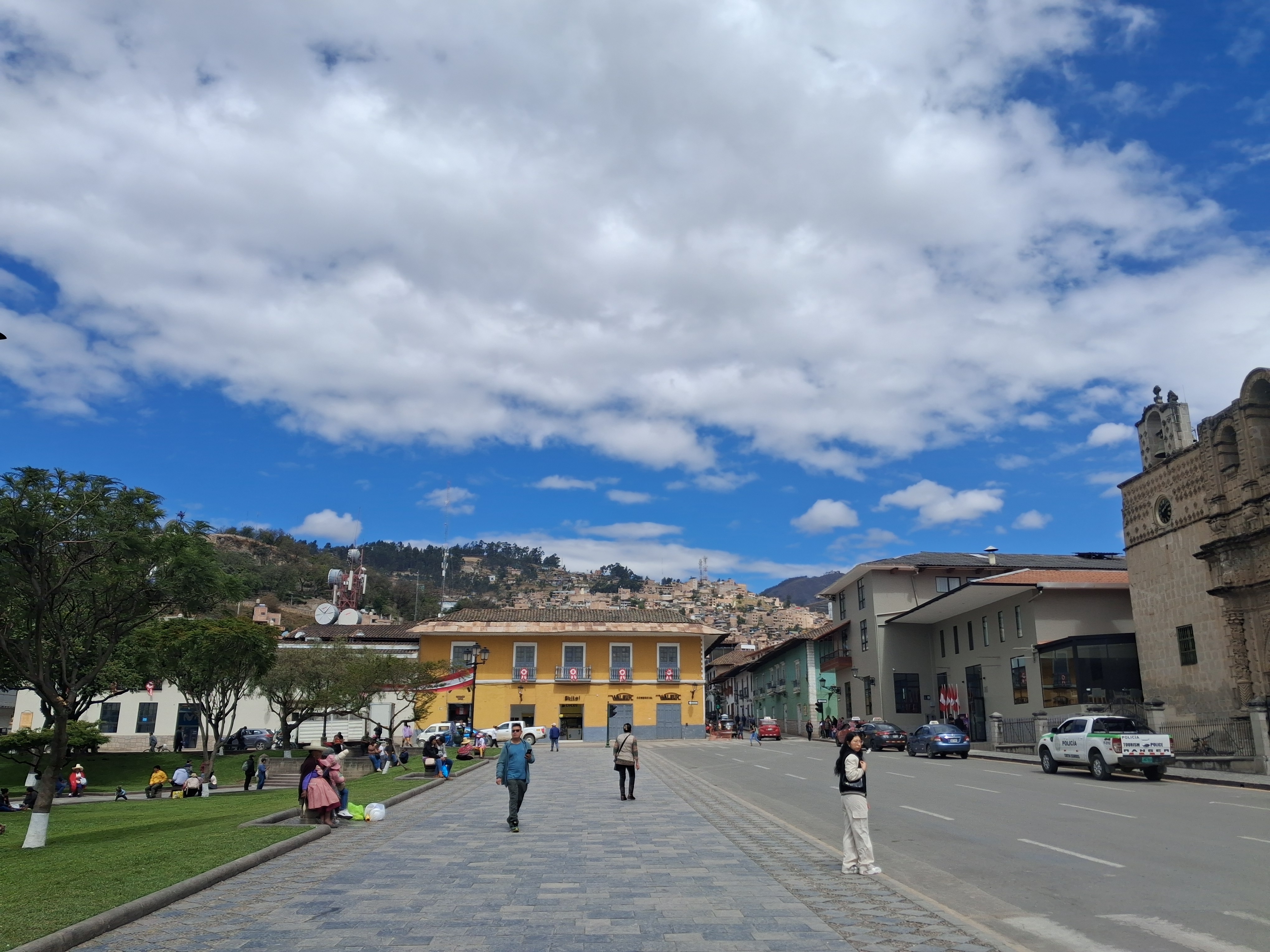
Open each photograph to pause over the fountain, facades, carved stone and shifting light that shape the experience of the square.
Andean context
Plaza de Armas de Cajamarca sits in the northern Andean valley of Peru, at 2,722 m elevation, where Inca and colonial layouts overlap. Before the Spanish arrival, this ground was already a meeting point of the Andean world; afterwards it became the civic and religious heart of the city that grew around it.
In November 1532, near this space, the forces of Francisco Pizarro met the Inca Atahualpa — an encounter that redefines the history of Peru. Local tradition links the square to the so-called Ransom Room (Cuarto del Rescate), where — according to the chronicles — gold and silver were gathered to pay for the Inca’s freedom. That room is a few minutes’ walk away and belongs to the same memory route.
The square’s edge is defined by churches from the 17th to 19th centuries: Cajamarca Cathedral, facing the fountain, and San Francisco Church, with its collection of colonial religious art. At the centre stands the octagonal stone basin that public sources date to the late 17th century and that a 1972 resolution declared a Historic Monument.
Three cues for looking
Orientation point · consider these cues before continuing your walk.
The octagonal basin visually organises the open centre.
Churches, facades and pedestrian paths frame the square’s perimeter.
This is a public space: give priority to people walking, resting and taking part in local activity.
Practical orientation
Plaza de Armas de Cajamarca is in the city centre of Cajamarca, Cajamarca, Peru. Traffic, stops, parking and service availability can change; confirm anything important on the day of your visit.
Cajamarca airport (CJA) is about 6 km from the centre, roughly 10–15 minutes by vehicle. Hire an authorised taxi at the airport stand or arrange transport in advance, and confirm the drop-off point and road conditions before leaving.
Interprovincial buses and combis arrive at the city terminals. From there, take a taxi, an urban transport vehicle or walk depending on your luggage and schedule; ask a staff member or the driver for the route before boarding.
Give “Plaza de Armas de Cajamarca” as the destination. Ride-hailing apps may not always be available, so agree on the route and, if possible, a fare before getting in. The centre has restrictions and temporary closures: watch for pedestrians and signage.
The site is in the city centre and pedestrian access is the immediate approach. Alight on a nearby street and use well-lit routes, especially after dusk.
MINCETUR’s public record lists free entry and a 24-hour access reference. The square is a public space and no admission charge is shown for walking through it. Transport, parking, purchases and private activities are arranged separately.
MINCETURFor a comfortable walk and a clear view of facades, choose morning or late afternoon; adjust to the weather and local activity. Allow 30 to 60 minutes for the square, and more if you continue through the historic centre.
Services around the square
This guide describes service types rather than recommending businesses. The official inventory notes accommodation and food offerings in the square and city, as well as banks, taxis, everyday shops and city service stations.
Ask about public facilities or customer services in nearby premises; availability and conditions of use may vary.
Consider authorised options away from the roadway. Confirm hours, capacity and rules before leaving a vehicle.
The centre includes restaurants, cafés, kiosks and other food formats. Choose according to your needs and confirm allergens directly.
The city offers hotels, hostels, neighbourhood shops and cash machines. Plan accommodation and use cash points only in secure locations.
Service stations are found in the city, not within the square’s pedestrian experience. Check route and vehicle compatibility before travelling.
Paving, edges and urban activity can affect mobility. If you need a specific accessibility condition, confirm through official channels before visiting.
Eating nearby, with care
Cajamarca’s urban setting includes restaurants, cafés, kiosks and soda-fountain formats. To preserve editorial independence, this guide neither ranks nor promotes businesses. Look for a choice that suits your budget, diet and time, then confirm ingredients, payment methods and hours directly.
When to go
Cajamarca has a highland climate: mild days from the elevation and cold nights, with a dry season and a rainy season. The table summarises the general pattern; confirm the local forecast before you leave.
| Season | Sky & rain | For walking & photos | Bring | Caution |
|---|---|---|---|---|
| Dec – Feb | Austral summer with sun and some afternoon rain; carnival in February. | Good light and a lively square; carry rainwear for showers. | Raincoat, dry footwear, a warm layer. | Evening rain; paving is slippery after rain. |
| Mar – May | Rain eases; green countryside and clear air. | Fresh scenery and clear skies for photos. | Light layer, sun protection. | Damp dirt stretches on the outskirts. |
| Jun – Sep | Dry season: sun, clear skies and cold nights. | Best light and stability for photographing facades. | Thermal wear, hat and light gloves. | Night frosts; very cold dawns. |
| Oct – Nov | Transition: rain returns gradually. | A fair mix of sun and cloud. | Packable raincoat, layered clothing. | Quick afternoon changes in weather. |
Based on Cajamarca's highland climate pattern (multi-year averages). It does not replace the official weather alert.
How to walk it
Three approaches by group and pace, plus two standard walks. The square is the starting point; nearby landmarks are a few minutes' walk away.
By type of visitor
A short, flat loop around the fountain, with rests on the benches and a snack at a café nearby. Avoid long climbs and keep children near the paved centre.
Arrive at dusk for golden light on the facades and the lit fountain; then climb Santa Apolonia Hill for the city panorama. Baños del Inca offers steam and reflections early.
Walk the main paved perimeter, where the surface is more even; go in the morning, when it is less crowded and the light is better. Rest in the side plazuelas.
Standard walks
Science & coexistence
A guide to the square is also a guide to the place: its elevation, its waters and its surroundings call for a few simple precautions. This is orientation only; it does not replace the official alert or medical advice.
Cajamarca sits at 2,722 m. Arriving from sea level, walk slowly for the first hours, drink water and avoid intense effort on day one. If you have a medical condition, check before travelling.
Baños del Inca are geothermal springs. Use the enabled facilities, respect opening times, and do not enter if local notices advise against it.
Santa Apolonia Hill and the surroundings host Andean birds and native vegetation. Do not feed animals or take plants; stay on the marked paths.
Carry your litter and use the provided bins for what you cannot take with you. In churches, lower your voice during ceremonies and dress appropriately for the space.
The square is a living public space: give way to people walking, mind the uneven paving, and prefer lit routes after dark. Confirm local conditions on the day.
Continue the walk
When visiting Plaza de Armas de Cajamarca, visitors can easily explore surrounding historical landmarks and points of interest, including Cajamarca Cathedral and the Ransom Room (Cuarto del Rescate).
A church opposite the square and a central visual reference in the historic ensemble.
Religious architecture that helps read the square’s urban edge.
A site historically associated with Atahualpa; confirm access conditions before going.
An urban high point for viewing the city’s relationship with its landscape.
An area known for thermal waters, beyond the square’s immediate walking circuit.
Location
The map is presented in Spanish, the local language of the area. Use it for orientation; for live route decisions, confirm traffic and access conditions in the mapping service.
Open location in Google MapsFor official updates and regional tourism information, visit the Peru / Cajamarca Official Tourism Portal of MINCETUR.
Google Plus Code: RFVM+62 Cajamarca, Peru
Frequently asked questions
MINCETUR’s record lists free entry. It is a public square; private services around it are arranged separately.
The public inventory lists a 24-hour access reference. Events, works, safety conditions and local changes may affect the visit, so confirm before leaving.
Thirty to sixty minutes lets you take in the square calmly. Add time if you plan to see other landmarks in the historic centre.
Availability is not constant and this guide does not recommend a provider. Ask about authorised parking and currently available facilities when you arrive.
Spanish is the language of local public information. This guide also provides an English version to help international visitors plan.
The square is linked to the 1532 encounter between the forces of Francisco Pizarro and the Inca Atahualpa. At its centre stands the octagonal stone fountain that public sources date to the late 17th century and that a 1972 resolution declared a Historic Monument. Read it as a living space, not a static backdrop.
Within a short walk you can connect with Cajamarca Cathedral, San Francisco Church, the Ransom Room (Cuarto del Rescate), Santa Apolonia Hill and Baños del Inca. Confirm each site’s access before going.
Sources & verification
This independent guide cross-checks its information against verifiable public sources. It contains no commercial recommendations and reproduces no reviews.
Image credits. Night photograph of the square: Wasaberta, CC BY-SA 4.0, via Wikimedia Commons. Read the source ↗
Your cookie choice. You can manage necessary and analytics cookies from the settings page. Go to settings →